Overview
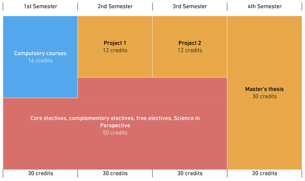
For the Master’s degree, students have to acquire a total of 120 credits. The curriculum consists of seven categories. In each of these categories, the minimum number of credit points indicated has to be acquired.
The compulsory courses teach general methodical skills in Geomatics and thereby form the basis for individual specialisation in the Master’s degree programme.
The compulsory courses are studied in the 1st Semester (Autumn Semester) and consist of the following four courses:
- Computational Methods for Geospatial Analysis (4 KP)
- Geospatial Data Acquisition (4 KP)
- Geospatial Research Methods (4 KP)
- Geospatial Reference Systems (4 KP)
If one of the four compulsory courses was already completed at ETH Zurich during the preceding (Bachelor's degree) programme, the Director of Studies may, on request, approve a different course as a compulsory course.
A reduction in the minimum number of credits required in the compulsory courses is not possible.
The core electives teach the central subject knowledge in selected areas of Geomatics. They can be freely combined without any particular specialisations being required. Together with the tutor, the students put together their own personal curriculum.
The complementary electives teach specialist knowledge in greater depth in the field of Geomatics and specialist knowledge in related disciplines.
All core electives can also be counted as complementary electives.
The free electives broaden specialist knowledge and serve the acquisition of in-depth knowledge in selected areas of expertise. Students may select individual free elective courses from the entire course catalogues of ETH Zurich and the University of Zurich.
Subjects recommended for the degree programme are listed in the course catalogue under "Electives".
The study programme Science in Perspective is taught by the D-GESS professorships of history, conflict research, literature and cultural studies, economics, development and co-operation, philosophy, political science, psychology, law, sociology and scientific research. SiP courses are also offered in cooperation with the Language Center of the University and ETH Zurich.
All "Science in Perspective" courses are found in the ETH Zurich course catalogue under "GESS Science in Perspective".
The projects teach the students in-depth specialist knowledge in the context of projects to be worked on independently in selected areas of Geomatics, promoting teamwork, project organisation and technical writing and presentation. The two projects are written under the supervision of two different Geomatics professorships, and each project extends throughout one Semester.
The Master’s thesis is the culmination of the Master’s degree programme and takes six months. It is led by a Professor of Geomatics. The students should provide evidence in their Master’s thesis of their ability to work independently in a well-structured and scientific manner.
To acquire the Master’s degree, certification of at least 120 credits in the corresponding categories is required. Certification within four years of the start of Master's degree studies entitles students to request the Master’s degree.
The following minimum requirements must be met per category:

A maximum of 130 credits are recognised for the Master's degree in the final academic record. The final grade is calculated as the weighted average of all grades listed.
All additional study achievements not required for the degree are listed on a separate page of the final academic record.
Please note that all study achievements completed at ETH Zurich are listed in the final academic record. This includes any fail grades (only the second attempt is listed in cases where performance assessments were repeated); “no shows” (where a student dropped out of or failed to appear at an examination); and the results of additional admission requirements.
Detailed information on subject content, performance assessments, etc. in individual subjects can be found in the course catalogue.
