Digital Underground: Learning from Singapore
Spatial planning in the underground is becoming increasingly important. As part of the pioneering project "Digital Underground", an international research team led by D-BAUG professors Martin Raubal and Andreas Wieser is developing a 3D map of the underground in Singapore. The digital twin will help to save time and costs in construction and increase worker safety. The mapping initiative has model character and could also find applications in Switzerland in the future.
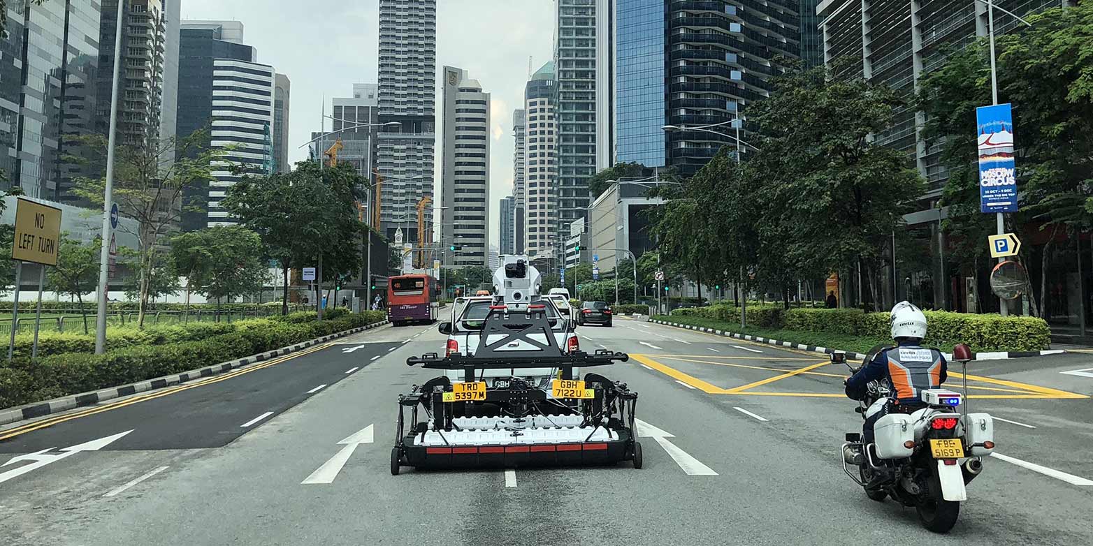
Singapore wants to improve its planning in the underground space. Until now, however, there has been a lack of data that document exactly the technical infrastructures running underground. "If you want to install a telephone line, service providers only know approximately where they have to dig up the street," explains Martin Raubal, principal investigator of "Digital Underground" and professor of geoinformation engineering at D-BAUG. "Utility maps indicate the location of pipelines with a possible deviation of up to ten meters. This can lead to accidents or delays in construction."
To overcome this lack of knowledge, the Digital Underground (DU) project was launched in 2017. The initiative is a collaboration between the Singapore Land Authority, the Singapore-ETH Centre (SEC) and the City of Zurich, and is the first attempt worldwide to develop new tools and standards for high-accuracy subsurface mapping in 3D. The project focuses on mapping the top subsurface layer where utility lines run.
“The service provider would not even dig up the road to begin with. Instead, the AR glasses would provide the exact, real-time image of the subsurface, making it possible to stake out a precisely defined area and to dig up the street in a more targeted manner.”Professor Martin Raubal
Construction with augmented reality
With a digital twin of the underground, infrastructure planning could become much more sustainable in the future. It would open up new possibilities for the use of augmented reality glasses, for instance. "In this kind of scenario, the service provider would not even dig up the road to begin with”, states Professor Raubal. “Instead, the AR glasses would provide the exact, real-time image of the subsurface, making it possible to stake out a precisely defined area and to dig up the street in a more targeted manner."
A prerequisite for such virtual planning is highly accurate data that precisely visualise the technical infrastructures underground. To achieve this, existing data is to be combined with new 3D data. But this is exactly where one of the challenges of the project lies. As the old data sets come from different service providers, such as telecoms and energy companies, who work with very different measurement methods and standards, the existing data pool is rather heterogeneous. Besides, getting the needed information can also be difficult, says the geoinformation engineer.
Better data thanks to quality control
Accordingly, one of DU's major tasks was first to obtain and analyse all existing data and – where technically possible – to convert it into a three-dimensional format. In a second step, the project team defined technical standards and regulations that outline how companies should measure. The current phase of the project involves the development of a quality platform and specific workflows by means of which submitted data can be precisely checked.
The idea is that in the future, all data will have to pass a quality test before being fed into a central 3D geodatabase. The information collected in this database would then form the basis for a digital twin of the underground that could provide all stakeholders with an overview of existing and planned infrastructure measures. Currently, the project team is testing the digital workflows with various service providers in a living lab. If all goes according to plan, the Singapore Land Authority could implement the project in two to three years.
“This kind of mapping for a sustainable infrastructure planning can only be accomplished, if all stakeholders sit at one table so that potential conflicts and competitions in the area of data exchange can be negotiated.”Professor Andreas Wieser
But DU is not just a technical project. In addition to harmonizing data and measuring practices, communication with the various stakeholders has played an essential role in the process, says Andreas Wieser, co-investigator of DU and professor of geosensors and engineering geodesy at D-BAUG. "This kind of mapping for a sustainable infrastructure planning can only be accomplished, if all stakeholders sit at one table so that potential conflicts and competitions in the area of data exchange can be negotiated." Also in this regard DU has model character, he suggests.
«Digital Underground CH», 6 September 2022
This one-day workshop aims at identifying the needs and required actions for establishing the digital underground of Switzerland, as well as at discussing the necessary frameworks and technological solutions. The workshop will be held in English. It comprises presentations by experts from Switzerland and abroad, as well as a moderated discussion among the participants. Registration required. More information here.